The north-east tip of Sardinia, where the La Maddalena archipelago faces the mainland around Palau, is one of the most beautiful small-boat cruising grounds in the Mediterranean: granite islands, white-sand coves and water so clear you can count the pebbles on the bottom. It is also full of rocks, shallow passages and gusty wind. Our live depth map covers the coast from Porto Pollo to the Golfo di Arzachena and the southern half of the archipelago, including La Maddalena town, Santo Stefano and the west coast of Caprera.
Depths on the map are at low water, though the tide in the Mediterranean is tiny, usually well under a foot. The map’s typical error is about 4 ft. Clear water helps, but the dark granite and seagrass bottom here are harder to read than white sand, and in water deeper than about 30 ft the map is less certain, so we show that as one dark colour.
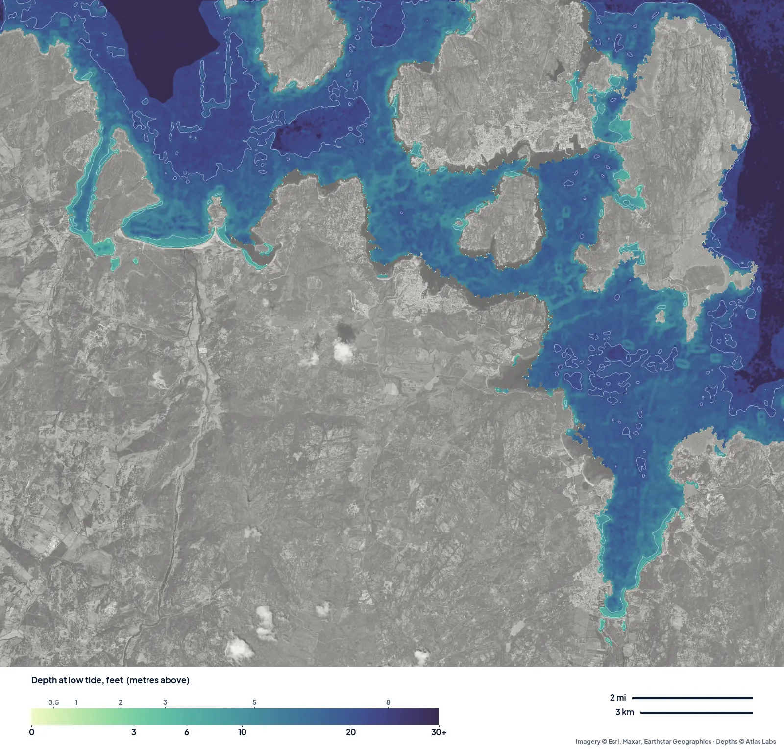
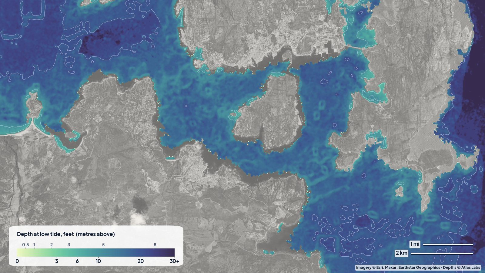
North-east Sardinia at low water. The mainland is grey at the bottom; La Maddalena, Santo Stefano and Caprera are the islands along the top and right; Porto Pollo is the bay with the tombolo on the left.
Porto Pollo and the Isola dei Gabbiani
On the left of the map, the bay at Porto Pollo is split by a thin sandy tombolo joining the mainland to the Isola dei Gabbiani. The water inside the bay reads about 6 to 9 ft, with a pale ring of shallower sand along the beaches. This is one of the best-known windsurf and kitesurf spots in the Mediterranean, because the wind funnels down the strait while the water stays flat and shallow near the beach. For paddlers it means: calm mornings only.
Palau and the channel to La Maddalena
Between Palau and La Maddalena the map shows a band of mid-depth water, reading roughly 9 to 16 ft in the parts it can see, with the ferry route running through it. The channel is busy all day in summer with ferries and tour boats, so kayakers should cross at right angles, quickly, and well away from the ferry docks.
The Golfo di Arzachena and Cannigione
The long inlet at the bottom right of the map is the Golfo di Arzachena. It is a sheltered, sandy-bottomed gulf: the map reads 12 to 17 ft down the middle and a pale fringe of shallower water along both shores, especially at its head. Off Cannigione, about halfway down the west shore, the map reads roughly 8 to 15 ft. That is why the gulf is a favourite anchorage when the mistral is blowing outside: good shelter, sand, and predictable depths.
Around the islands
Around La Maddalena, Santo Stefano and Caprera, the map shows small pale patches in the coves and bays, the shallow sandy spots that make the archipelago famous, and darker water in the passages between the islands. The archipelago is a national park with zoned access, fees for boats and rules on anchoring and landing, so check the park’s current rules before you go.
Planning tips
- Wind first. The mistral (maestrale) can blow hard for days, funnelling through the Strait of Bonifacio. Plan anchorages and paddles around the forecast, not the map.
- Rocks: granite boulders rise from the sand everywhere here, often too small to show on a satellite map. Approach coves slowly and keep a lookout at the bow.
- Kayaks and paddleboards: the Golfo di Arzachena and the inside of Porto Pollo bay are the easiest water; crossing to the islands is for calm days and experienced paddlers.
- Anchoring: anchor on sand, not on the seagrass meadows, which are protected.
Open the live map
Tap any spot for the depth in feet: La Maddalena and Palau live map. For other areas, see all spot hubs.
Frequently asked questions
How deep is the Golfo di Arzachena?
Our map reads about 12 to 17 ft down the middle of the gulf, shallower along the shores and at its head.
How deep is the water at Porto Pollo?
Inside the bay the map reads about 6 to 9 ft, shallower along the beaches, which is why it is so popular for windsurfing and kitesurfing.
Is there a tide in Sardinia?
Only a very small one, usually well under a foot. Wind and air pressure change the water level about as much as the tide does.
Related reading
- Exumas sandbanks around Staniel Cay
- Jebel Dhanna shallow water depth map
- How accurate are satellite depth maps?
Safety note: ShoalScope depth maps are satellite estimates for planning, not for navigation. Use official charts and pilot books, respect the national park rules, and always wear a life jacket.