The Abacos are the northern Bahamas’ sailing capital: a long main island (Great Abaco) with a chain of barrier cays a few miles off its east coast, and between them the Sea of Abaco, a sheltered sound of shallow turquoise water with Marsh Harbour as the hub and Hope Town, Man-O-War Cay and Great Guana Cay as the classic stops. Hurricane Dorian in 2019 devastated the area, and the islands have been rebuilding since. The water, however, is as it was: shallow, clear and easy to read. This guide covers typical depths by zone, harbour entrances, launches, tides and hazards. The satellite depth map for this cell is updated regularly.
What the bottom looks like
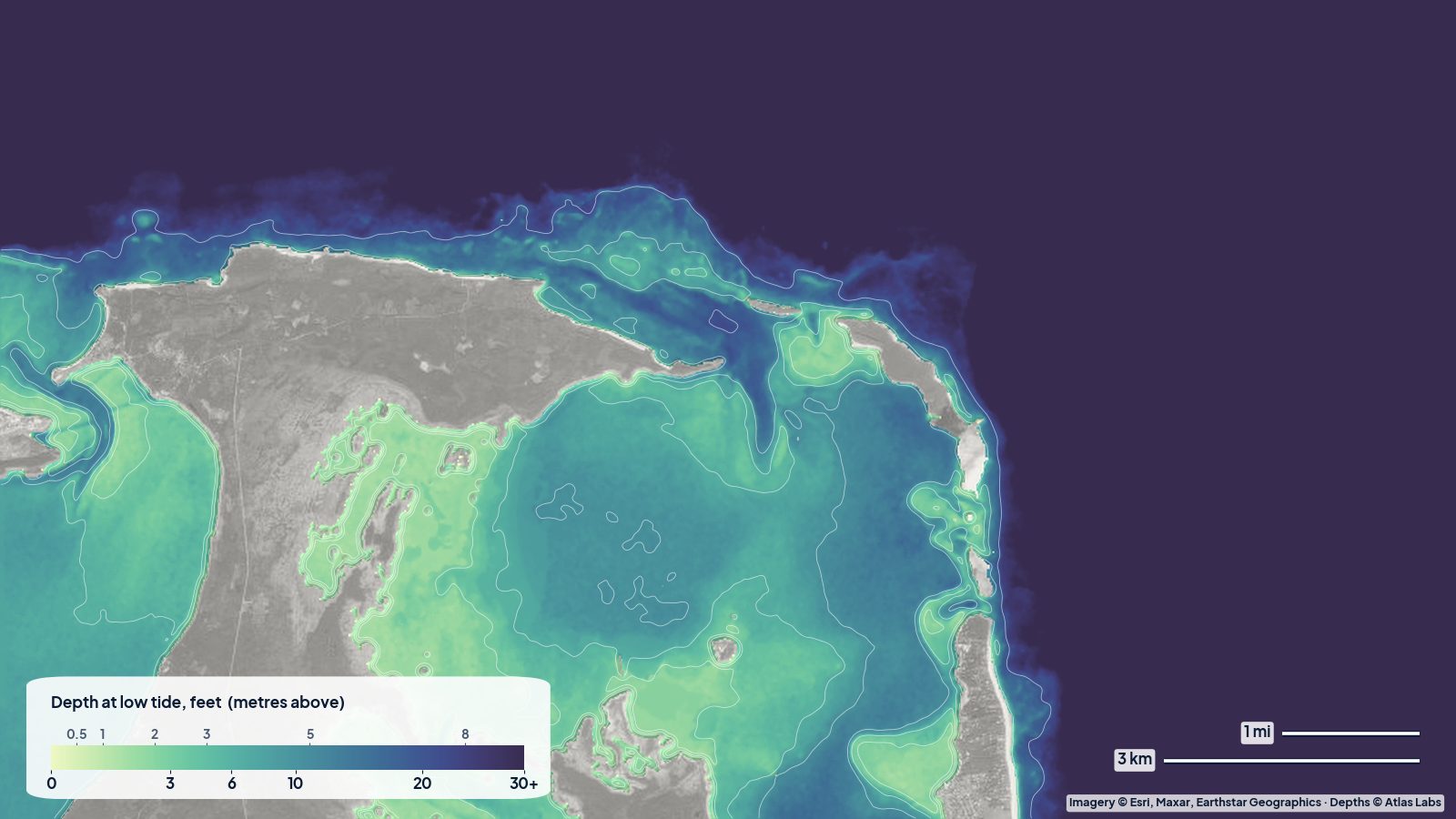
- Sea of Abaco: a broad sound of white sand and seagrass, mostly shallow, with a deeper main channel used by ferries and yachts and sandbars that build off the points of the cays.
- Harbour entrances (Hope Town, Man-O-War, Marsh Harbour): narrow, marked channels through sand and rock into well protected harbours with moorings and docks.
- Sandbars and beaches: Tahiti Beach at the south end of Elbow Cay, the Guana Cay sandbars and many others dry or go ankle deep at low tide and are the favourite stops for dinghies, kayaks and paddleboards.
- Barrier reefs: on the ocean side of the cays, the Abaco barrier reef runs for miles in shallow water, with named snorkel sites such as Fowl Cays, Sandy Cay and Mermaid Reef (the last inside the sound off Marsh Harbour).
- The Marls (west of Great Abaco): a vast shallow mangrove and flats wilderness famous for bonefish, reached from the west side of the island.
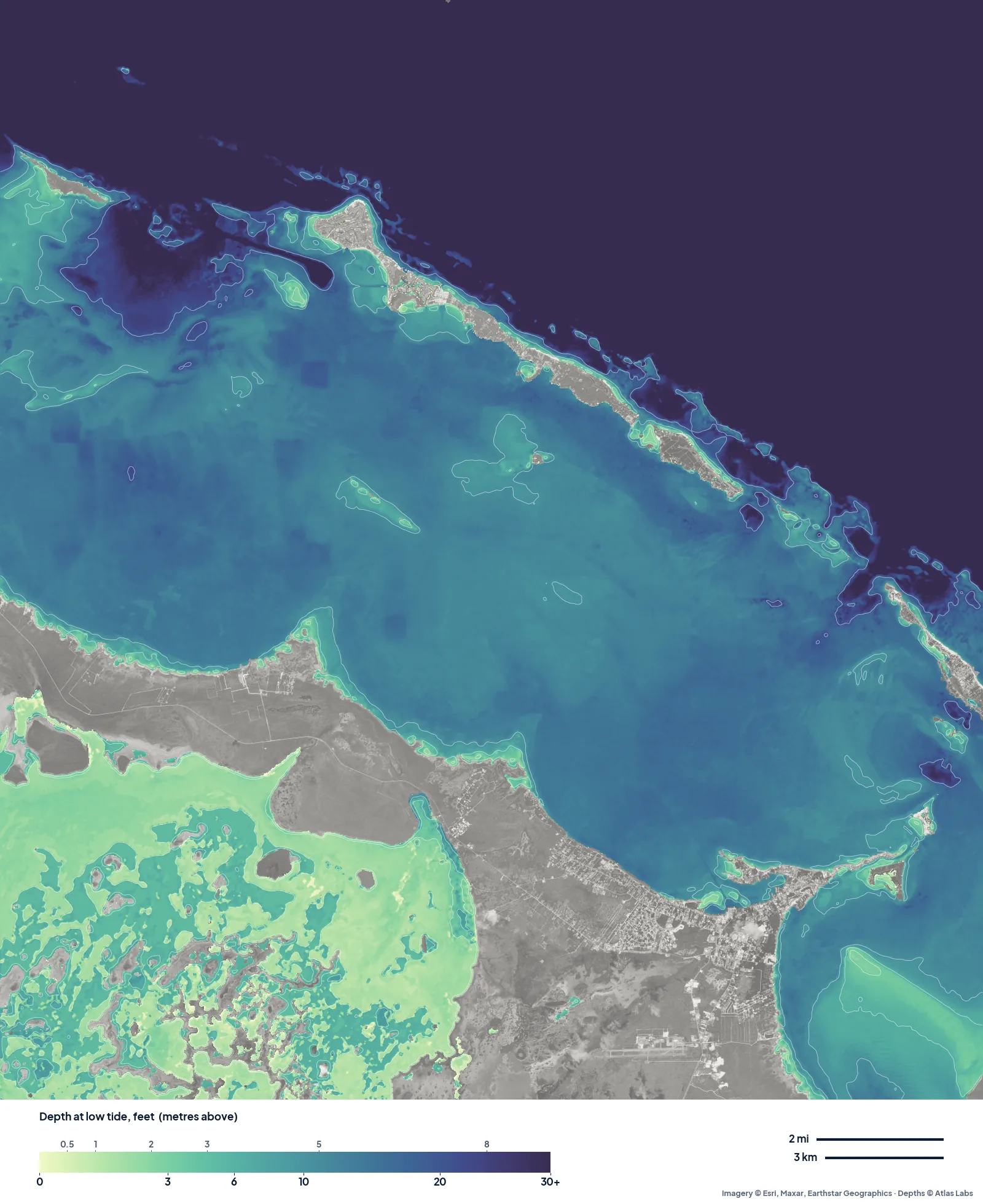
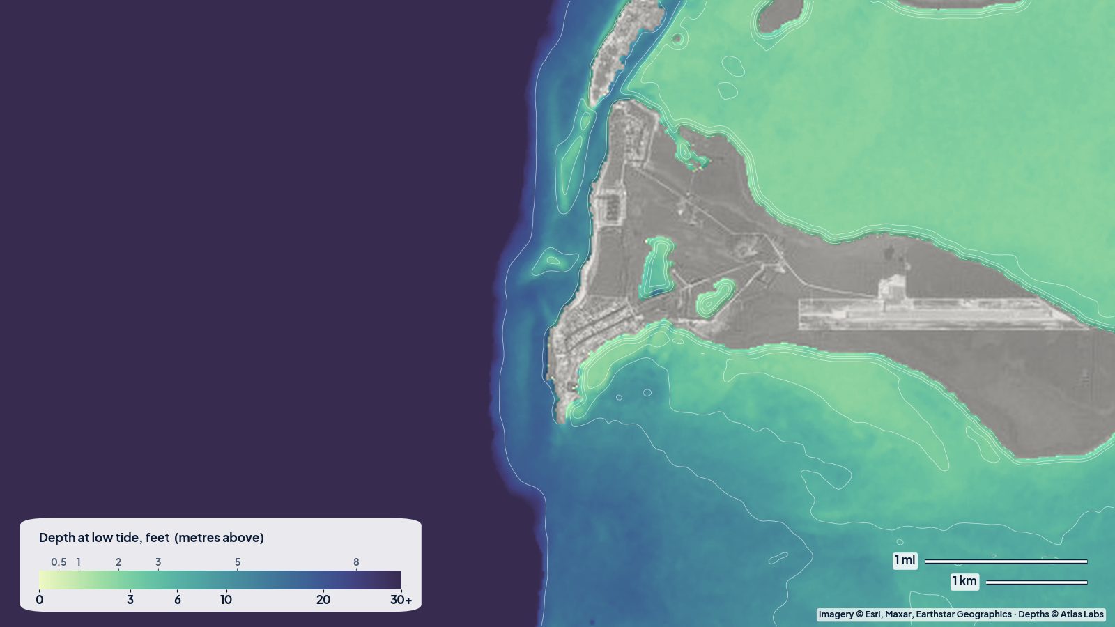
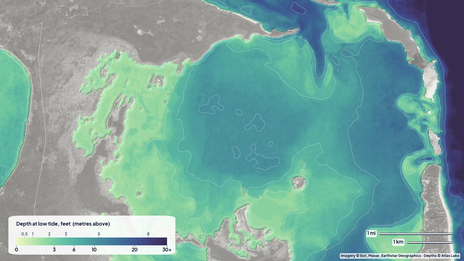
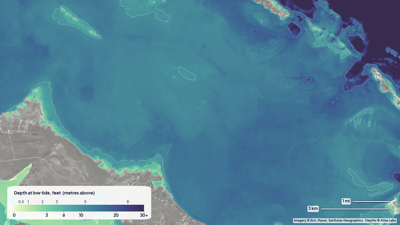
The real depth map of the Sea of Abaco at low tide. Most of the sea sits in the 10 to 20 ft band; the pale water along the Abaco mainland and in the bights is the shallow, sandy margin. Tap any spot on the live map for a number.
Approximate depth by zone
Typical ranges only. The tide range is roughly 2.5 to 3.5 ft (0.8 to 1.1 m), and it matters at every harbour entrance and sandbar. Check the live map and the tide.
- Sea of Abaco main channel: roughly 8 to 20 ft (2.4 to 6 m) along the ferry routes.
- Open sound away from the channel: roughly 4 to 12 ft (1.2 to 3.7 m), with sandbars shoaling to nothing off the points.
- Hope Town harbour entrance: cruising guides quote roughly 4 to 6 ft (1.2 to 1.8 m) at low water at the shallowest; inside the harbour roughly 6 to 10 ft (1.8 to 3 m).
- Marsh Harbour anchorage: roughly 6 to 10 ft (1.8 to 3 m), with a marked entrance.
- Man-O-War Cay harbour entrance: narrow and shallow, roughly 5 to 7 ft (1.5 to 2.1 m) at low water.
- Tahiti Beach and the Guana sandbars: dry to 2 ft (0 to 0.6 m) at low tide; 3 to 5 ft (0.9 to 1.5 m) at high.
- Mermaid Reef (Marsh Harbour): roughly 5 to 15 ft (1.5 to 4.6 m), snorkel from the beach.
- Barrier reef snorkel sites (Fowl Cays, Sandy Cay): roughly 5 to 25 ft (1.5 to 7.6 m), moorings provided.
- The Marls: roughly 6 in to 3 ft (15 to 90 cm), skiff and kayak only.
Access, launches and anchorages
- Marsh Harbour: the airport, the main marinas, fuel, provisioning and the ferry hub; public docks and a ramp for trailerable boats.
- Hope Town (Elbow Cay): moorings in the harbour, the candy-striped lighthouse and golf-cart rentals; kayak and paddleboard rentals in the settlement.
- Man-O-War Cay and Great Guana Cay: small harbours with moorings and docks; Guana’s ocean beach and sandbars are a short walk from the harbour.
- Treasure Cay: a marina and a long beach to the north, with a ramp.
- The Marls and the west side: guides launch skiffs from the west coast of Great Abaco and from Sandy Point in the south.
- Charter bases: several bareboat companies operate from Marsh Harbour and Hope Town; dinghy and kayak exploration of the sandbars is part of every itinerary.
Best tide, wind and season
- Tide: Enter Hope Town and Man-O-War harbours at mid to high tide if you draw more than 4 ft (1.2 m). Visit the sandbars an hour either side of low tide for walking and at high tide for swimming. Snorkel the barrier reef at slack or on a rising tide for clarity.
- Wind: The trade wind from the east and south-east is steady; the Sea of Abaco is protected from ocean swell by the cays but gets a short chop in strong winds. Winter cold fronts bring northerlies and westerlies that make some anchorages uncomfortable and close the reef passes.
- Season: December to April is the sailing high season, with regattas in spring. Summer is hot and calm with the clearest water; hurricane season peaks August to October.
Hazards
- Harbour entrances: Narrow, shallow at low water and busy with ferries and dinghies. Follow the markers and current local guidance; Dorian moved some sand.
- Sandbars off the points: They build and move; the bar off Tahiti Beach and those off Guana regularly catch dinghies at speed.
- Ferry and boat traffic: The Albury’s Ferry routes and the charter fleets are busy; paddlers should stay out of the main channel.
- Reef passes: The gaps in the barrier reef to the ocean have current and breaking swell; snorkel inside only unless flat calm.
- Rebuilding infrastructure: Services on some cays are still limited; check ahead for fuel, water and moorings.
- Sun and dehydration: No shade on the water or the sandbars.
Kayak and boat draft guidance
Kayaks and paddleboards (4 to 6 in, 10 to 15 cm of draft) can explore every harbour, sandbar and shoreline in the Sea of Abaco, and the lee of the cays is calm in trade winds. Hope Town harbour to Tahiti Beach is about 2 miles (3 km) along the sheltered inside of Elbow Cay.
Charter monohulls and catamarans drawing 4 to 6 ft (1.2 to 1.8 m) can sail the sound and enter the main harbours at the right tide; the shallowest entrances need mid tide or better. Dinghies and skiffs drawing 6 to 18 in (15 to 45 cm) can reach the sandbars and the Marls but still ground at low tide. Allow at least 1 ft (0.3 m) above your draft, more on a falling tide.
Frequently asked questions
How deep is the Sea of Abaco?
The main channel is roughly 8 to 20 ft (2.4 to 6 m) and the open sound roughly 4 to 12 ft (1.2 to 3.7 m), with sandbars shoaling to nothing off the points of the cays.
How deep is the Hope Town harbour entrance?
Cruising guides quote roughly 4 to 6 ft (1.2 to 1.8 m) at low water at the shallowest point, so boats drawing more than 4 ft (1.2 m) should enter at mid to high tide.
Where are the best sandbars in the Abacos?
Tahiti Beach at the south end of Elbow Cay and the bars off Great Guana Cay are the favourites, best an hour either side of low tide.
Can I snorkel from shore in the Abacos?
Yes, at Mermaid Reef in Marsh Harbour and off the ocean beaches of Guana and Elbow cays on calm days. The barrier reef sites are reached by dinghy or tour boat.
Is the Sea of Abaco good for beginners?
Yes, it is one of the easiest cruising grounds in the Caribbean region: short distances, sheltered water and good holding, as long as you respect the tide at the harbour entrances.
Related reading
Safety note: ShoalScope depth maps are satellite estimates for planning only and are not for navigation. Harbour entrances and sandbars moved after Hurricane Dorian. Use official charts and current cruising guides, and enter harbours in good light.